Open topic with navigation
About DLS Coordinates
The coordinate system = - SEC - TWP - RGE W/MER
Valid numbers in each box are:
- : 1-16
- : 1-36
- : 1-126 (Mandatory)
- : 1-34 (Mandatory)
- : 1-6 (Mandatory)
The Dominion Land Survey (DLS) grid covers most of Western Canada's
sedimentary basin, and it is the survey system used in Alberta, Saskatchewan, a portion of Manitoba, and the Peace River Block in British Columbia. DLS divides land into regular boxes called townships,
which are 6 miles on each side. Three coordinates (Township, Range, and
Meridian), identify each township. GeoVista uses a township and range coordinate pair, in conjunction with a meridian
number, to identify a specific township in the DLS. The following explains
the numbering, using the example 89-9-W-4.
- 89
(the township numbering) - Townships are numbered from 1 to 126, south-to-north.
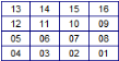
Each DLS township is divided into 36 sections, which are one mile on a
side and numbered in a left-to-right/right-to-left pattern.
- 9
(the range numbering) - Ranges are numbered from 1 to 30, east-to-west,
at township 1, and from 1 to 23, east-to-west, at township 126. Each DLS
section is divided into 16 Local Subdivisions (LSD), which are 1320 feet
on a side and numbered in the same way as the sections.
- Due to the curvature of the earth,
there are fewer ranges between meridians at the northern extreme of the
DLS area than at the southern extreme.
- W
4 (the meridian) - A meridian is a broad group of ranges, with
W4 meaning west of the 4th meridian.
A DLS township showing section numbering
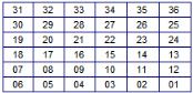
A DLS section showing LSD numbering