Open topic with navigation
3D Rectangular Resurvey Properties Dialog Box
Use the 3D Area Resurvey option
if you have re-shot an area or have access to more accurate information,
and you want to incorporate the new data into your project without reloading.
Follow these steps:
- On the Application
toolbar select
 | Resurvey |
3D Areas to open the 3D
Rectangular Resurvey Properties dialog box, where you can enter
new coordinates to shift or resize the 3D area.
| Resurvey |
3D Areas to open the 3D
Rectangular Resurvey Properties dialog box, where you can enter
new coordinates to shift or resize the 3D area.  View image
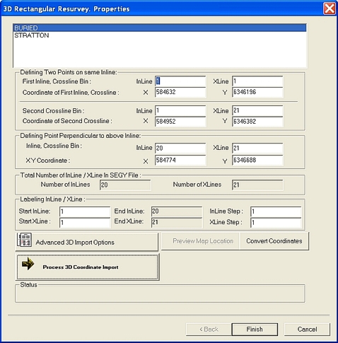
- In the field at the top of the dialog box, select
the 3D area you want to resurvey.
- In the Defining
Two Points fields, change the values to incorporate your new data.
The new coordinates will shift or resize the 3D area.
- Refer to the 3D
Rectangular Import wizard for more information about inline
and coordinate values.
- In the Defining
Point Perpendicular fields, type the coordinates of a third point
that falls on one of the cross-lines of the first two points. This provides
the new cross-line bin size and geometry of the 3D data area.
- In the Total
Number of InLine/ XLine in SEGY File field, type the total number
of in-lines/ cross-lines in your SEG-Y file. Remember that WinPICS
assumes that you have sorted your file in the in-line direction.
- In theLabelling
InLine/ XLine fields, type the values of the start InLine and start
XLine for the area you want to resurvey.
- Click <Process
3D Coordinate Import> to import the new data values into your
project. The Inline
and Crossline Bin Sizes dialog will appear and ask you to confirm
the bin sizes by selecting <Yes>
or <No>.
- If you want to resurvey another 3D area, repeat steps 2 to 7 now.
- Click <Finish>
to incorporate the new data to your project and redraw the map.
What do you want to do?