View image
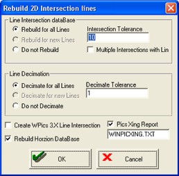
The Rebuild 2D Intersection Lines dialog box displays as the last step towards converting the parameters for your new project. This dialog box finds intersection locations for 2D lines, creates a text file containing the line locations and intersections, produces a decimated coordinate file for quick map displays, and updates the horizon definition table (database).
Typically, you will accept the default settings on this dialog box. However, if you have curved lines or lines that intersect more than once, you can change the settings to make it easier to work with your data and to provide better map posting.
This dialog box has the following options:
| Option | Description |
|---|---|
| Rebuild for All Lines | Recalculates intersections for the entire project. |
| Rebuild for New Lines | Calculates intersections for new data only. |
| Do Not Rebuild | Select only if you are performing a line decimation and/or horizon rebuild. |
| Intersection Tolerance | Type in a value as the maximum distance for an intersection in UTM map units. ProductName looks for shotpoints on other lines that are within a radius of the shotpoint of interest. This radius is equal to the intersection tolerance. ProductName considers shotpoints that are further away then the intersection tolerance to be part of non-intersecting lines. |
| Multiple Intersections with Lines |
|
| Decimate for All Lines | Creates new decimated coordinate files for the entire project. |
| Decimate for New Lines | Creates decimated coordinate files for new data only. |
| Do Not Decimate | Select this option if you are only rebuilding intersections and/or horizons. |
| Decimate Tolerance | Type in a value to control the length of line segments drawn on map displays and plots. For straight lines, the default 20 is appropriate. Set a smaller decimation for better representation of curved lines. |
| Create WPics 3X Line Intersection | Select this check box to provide backward compatibility with ProductName 3.X versions. |
| Rebuild Horizon Database | Select this check box to scan all 2D and 3D pick files for horizon information and update or create a horizon definition table (horzdefn.db). If a current horizon definition table exists, ProductNamewill update it without changing the current settings. If no table exists, ProductName will create it by assigning default colors and a Peak event type. |
| Pics Xing Report | Select this check box to create a text file listing each 2D line and the trace locations for line intersections. ProductName overwrites this file each time you recalculate line intersections. Use a text editor (such as Notepad) to read the file. |
| <OK> | Click to complete the projection conversion. |
| <Cancel> | Click to cancel the changes. |
What do you want to do?