Open topic with navigation
About NTS Coordinates
The NTS coordinate system = QTR - UNIT - BLK / SHEET - SUBDIVISION - BLOCK
Valid numbers in each box are:
- : a-d
- : 1-100
- : A-L (Mandatory)
- : 1-117 (use 92-94 range, which covers BC, Canada) (Mandatory)
- : A-P (Mandatory)
- : 1-16 (Mandatory)
The National Topographic System (NTS) grid covers all of Canada. It is used for oil and gas mapping in British Columbia (in all areas except a small portion of British Columbia and the Fort St. John area (referred to as the Peace River block), which is surveyed by TWP). The remainder of the province is unsurveyed and uses the NTS mapping system that divides the area into grid areas, blocks, and units. You specify NTS coordinates using the following:
- - Represents areas that are 4 degrees from north-to-south and 8 degrees from east-to-west. In BC, primary subdivisions are numbered from 82-to-114, but most of the active oil and gas occurs in primary subdivisions 93 and 94.
- - Represents areas that are 1/16 of a primary quadrangle. These are lettered from A-to-P, in a left-to-right/right-to-left pattern, starting at the southeast corner of the primary quadrangle.
- - Represents areas that are 15 minutes-by-30 minutes in size or 1/16 of a lettered quadrangle. They are numbered from 1-to-16, in a left-to-right/right-to-left pattern.
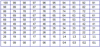
- - Each Sixteenth (portion) is divided into 12 blocks that are 5 minutes wide-by-7.5 minutes high. Blocks are lettered from A-to-L, in a right-to-left/left-to-right pattern. Each block is divided into 100 units that are 30 seconds wide-by-45 seconds high and numbered from 1-to-100.
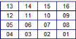
- - Each unit has four quarters. There are 100 units in 1 block, with units numbered from 1 to 100.
- - Numbered A, B, C, and D, in the same style as DLS grids.
An NTS primary subdivision showing subdivision lettering

An NTS subdivision showing sixteenth numbering
An NTS sixteenth showing block lettering

An NTS block showing unit numbering