To open the Spatial
Search Options dialog box, select Map
| Perform Spatial Query from the Main
Menu bar, or, click ![]() on the Map Tools toolbar. The Perform
Spatial Query option enables you to search for facilities and wells
within an area using a geometric shape.
on the Map Tools toolbar. The Perform
Spatial Query option enables you to search for facilities and wells
within an area using a geometric shape.
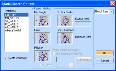
Select the database that you wish to search. You can select from a standard database, or you can select one of your result sets and refine your results by searching a particular area. If your selection doesn't match the area you are searching, you will receive a pop-up warning. For instance, if you viewing a map of Alberta and attempt a search of Manitoba wells (MB_WELLS database) you will receive the following error message:
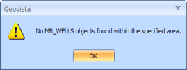
Change your database selection or move to another coordinate area on the map and try the spatial query again.
Select this option if you wish to draw a boundary line on the map after you have run the query.
Determine how the area will be drawn for your query. Every object within the drawn geometric will be included in the query.
- Use Drawn Polygon - Create a polygon by clicking from point to point to point; GeoVista draws lines between the points to create the polygon. If you want to delete the last point you drew, press <Backspace> on your keyboard, or press <Escape> to cancel drawing the polygon entirely.
- Get Boundary From File - Check to open a boundary template file to create your polygon such as the PSAC Area files in .PGF.
Select your end result set from the drop down list. The selections are Wells, Transportation, Pipelines & Facilities, Watershed, Grid, Culture, and Land.
Click <OK> to accept your query options or <Cancel> to clear the query.