Points are one of the data types that you can work with in the Map window's Object Manager.
You can import existing points into your project by using the Import | Import Points menu option in the toolbar. Follow these steps:
 | Import Points to open the Select Points Files to Import dialog box.
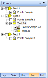
The points data itself displays in WinPICS as a named point set. You can organize point sets into groups, which are folders in the Object Manager. Use the Object Manager to create a new group of points. Read more
Use the Points tab shortcut menu to edit, merge, rename, and perform other actions on the points.
You can select points as an attribute when you set up your gridding. The points you use should be compatible with the type of data you're gridding. So if you want to grid on horizon time, then the points data should be in milliseconds.
What do you want to do?