 View image

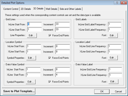
 How to open the 3D details tab
Edit these parameters to control the in-line/cross-line grid density.
For example, if you set In-line Ref = 10, In-line Increment = 10, X-line Ref = 10, and X-line Increment = 20, then as a result you will get in-lines 10, 20, 30, etc. and cross-lines 10, 30, 50, etc.
Edit these parameters to set the label frequency of your in-line/cross-line grid lines.
Edit these parameters to set the frequency of in-line/cross-line intersection symbols.
For example, if you entered In-line Ref = 10, In-line Increment = 20, X-line Ref = 10, and X-line Increment = 40, you would see the following results:
| in-line10/ cross-line10, in-line10/ cross-line50, in-line10/ cross-line90, etc. |
| in-line30/ cross-line10, in-line30/ cross-line50, in-line30/ cross-line90, etc. |
| in-line50/ cross-line10, in-line50/ cross-line50, in-line50/ cross-line90, etc. |
Edit these parameters to set the label frequency of your in-line/cross-line intersections. WinPICS
Edit these parameters to control the numeric 3D horizon value symbols at the in-line/cross-line intersections.
For example, if you set In-line Ref = 10, In-line Increment = 20, X-line Ref = 10, and X-line Increment = 40, then you will see the following results:
| in-line10/ cross-line10, in-line10/ cross-line50, in-line10/ cross-line90, etc. |
| in-line30/ cross-line10, in-line30/ cross-line50, in-line30/ cross-line90, etc. |
| in-line50/ cross-line10, in-line50/ cross-line50, in-line50/ cross-line90, etc. |
Edit these parameters to control the frequency of numeric 3D horizon values posted on your map at the in-line/cross-line intersections.
What do you want to do?