Open topic with navigation
Seismic Scales Tab
Use the Seismic
Scales tab to set the scale for your wiggles and traces in the
Seismic
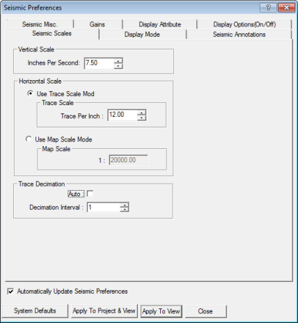
view.  View image

This tab has the following options:
Vertical scale
Enter a value for the number of inches per second to use to display
the traces.
Horizontal scale
WinPICS can draw traces at
trace scale or at map scale. Trace scale draws your seismic with a fixed
distance (in TPI) between traces, while map scale is variable and presents
a spatially accurate representation of the traces.
Trace Scale
To draw your traces at trace scale, follow
these steps:
- Select the Use Trace Scale Mode option.
- In the Traces
Per Inch field, select the number of traces per inch, as shown
in the Seismic
display, you want WinPICS to
draw.
Map Scale
To draw your traces at a map scale, follow these steps:
- Select the Use Map Scale Mode option.
- In the Scale
1 field, type the scale, as shown on your map, you want WinPICS
to draw traces at. The default setting is the scale of your current map.
For example, a scale of 1:20000 means your traces will be drawn so they
match the length of your line at a map scale of 1:20000 meters.
- The Map Scale
feature is useful for comparing two seismic vintages with different trace
spacing.
Trace Decimation
Trace decimation controls
how many seismic traces WinPICS
displays. You have the following options:
- Auto -
Select to have WinPICS automatically
decimate traces displayed on the seismic window based on the selected
scale.
- Enter a number to customize how many seismic traces
WinPICS displays. A setting of
1 means that WinPICS displays
every trace; 2 means that every other trace is displayed, etc.
What do you want to do?
 View image
 View image