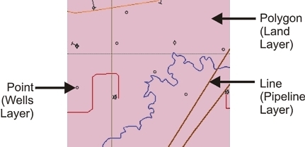
By default, GeoVista draws layers on your map from the bottom of the Layer Manager tab to the top, drawing polygons first, then lines, and finally points. GeoVista looks from the bottom of the tab to the top of the tab for polygons (For example, land), and then draw each one as it finds it. Then, it will start over again at the bottom, but this time it will look for lines to draw (For example, pipeline layers). Finally, it will look from bottom to top for points to draw (For example, wells).
This drawing style is called Smart Draw Ordering, and it is important because it ensures that no objects are hidden in the Map View. For example, if the wells layer was drawn before the land layer, you would not be able to see any wells because the land layer would hide them.
What do you want to do?