GeoVista and WinPICS work together to form a unique and dynamic feature called VistaBridge. This feature enables you to temporarily integrate GeoVista's rich and current geological database information with the WinPICS geophysical basemap, only when you want it. Integrate your geological and geophysical maps using VistaBridge to enable two applications to draw in one map.
Geophysicists no longer need to update their basemap prior to making drilling or land decisions because their WinPICS basemap displays all the information on one map. The richness and currency of a geological basemap is now in WinPICS.
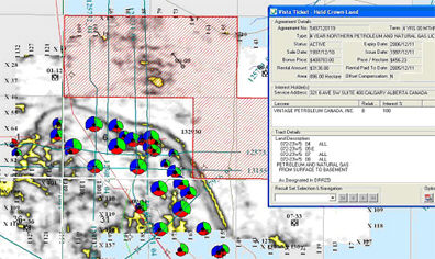
You automatically stay up to date with all activity in your prospect area. Land questions such as who owns the land, and when does it expire, or what was the price of the land, or which acreage is posted in the next land sale are all current and always available on your WinPICS maps.  View image
Refine your geophysical interpretation with direct online access to Divestco's digital and raster log inventory. Not only can you query WinPICS maps for wells with acoustic logs, but also you can search for logs from the deepest wells with production or the newest logs available. When logs from a competitor’s new discovery are publicly released, you can retrieve them from your WinPICS basemap.
VistaBridge delivers solutions for WinPICS users
- Online Curve Retrieval
- Production Histories
- Land Sale Postings
- Mineral Rights Holdings
VistaBridge delivers up to date oil and gas data
- Raster Logs
- Scanned Well Documents
- Air Photos
- Land Sale Results
- Facilities and Pipeline Specifications
- Multi-User Formation Top Database

Use VistaBridge in WinPICS and GeoVista
Click on one of the following links to learn more about how VistaBridge works in each application: