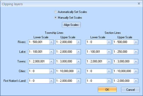
To open the Clipping Layers dialog box, select Map | Manage Clipping Layers from the Main Menu bar. Clipping enables you to fully view an object’s position on the grid by drawing the township lines or section lines directly on top of the object. You can use these lines to see where the river, lake, town, city, or first nations land lies on your land area. Depending on how you set your zoom options on the Mouse & Zoom Options dialog box, some objects in your map will display over township or section lines (they are not clipped), while others will display behind the lines (they are clipped). Use the options on this dialog box to determine when to clip an object.
By default, GeoVista is set to automatically clip objects at standard zoom levels. However, you can click the Manually Set Scales option to set these options to your own preference.
To further understand what happens with clipping, take a look at the following examples. We used the GeoVista default clipping zooms for each example.
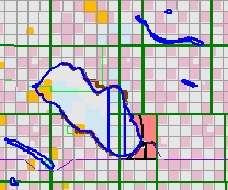
In this example, you can see how to make a lake object clip section lines.
|
|
|
|
Figure 1 - Lake not clipped (Left). |
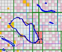
Figure 2 - Lake clipped (Right) |
In the figure on the left, we zoomed the map to 1:500,001. If you look in the Clipping Layers dialog box under Section Lines, you will see that Lake has a Lower Scale set to 1:100,001, and an Upper Scale set to 1:500,000.
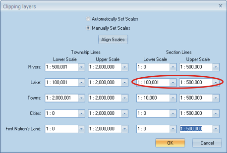
Because we zoomed to 1:500,001, the area falls outside the clipping scale, and the lake object covers any section lines behind it.
However, in the figure on the right, we zoomed to 1:500,000, which is inside the clipping area. Notice how the section lines appear on top of the lake object?
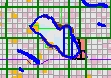
In this example, you can see how to make an object clip township lines.
|
|
|
|
Figure 3 - Lake not clipped (Left). |
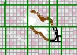
Figure 4 - Lake clipped (Right). |
In the figure on the left, we zoomed to 1:1,000,000. If you look in the Clipping Layers dialog box, you will notice that the clipping range for Lakes on Township Lines is 1:1,000,001 to 1:2,000,000.

Therefore, the left figure at 1,000,000 is not clipped by the township lines, so it will appear on top of the lines. However, in the figure on the right, we zoomed to 1:1,000,0001, which is within the clipping range, and the lake displays behind the township lines.
What do you want to do?