Open topic with navigation
Compute Depth Control Points
The Compute Depth Control Points
function is used to generate a well tops depth coordinate file to use
as an input data source when creating horizon grids.
- On the Application toolbar select
 |.
|.
- Highlight the wells which control points are to
be calculated. (Multi-selection of wells can be accomplished using the
<Shift> and <Ctrl>
keys).
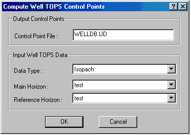
- Select , then ".
 View image

- Only the wells with tops that have an associated
horizon, will be saved to the control point file.
- Select the Input
Well TOPS Data type to use for the calculation. The data value
in the file can be written as a depth below KB or as a calculated Isopach
value. A main and reference horizon to create an isopach. The control
points file is saved in the current project folder and is written in ASCII
format.
What do you want to do?
 |Well
Database.
 View image
 |Well
Database.
 View image