Open topic with navigation
Batch
Processing
Apply line tie corrections to your current line and/or multiple 2D lines
and 3D areas or save your line tie parameters without applying the corrections.
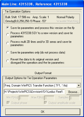
After making line tie corrections in the Tie with Diagnostics dialog box, click <OK>.  View image

A summary of the line tie corrections appears
at the top of the window.
This dialog box has the following options for saving your diagnostic adjustments:
- Save tie parameters
and process this version on the fly - Applies corrections
on the fly and does not process a new seismic version. Specify
the filename at the bottom of the window under Output
Format.
- No new seismic
version is created for phase and filter corrections. Corrections made
are displayed on the fly.
- Process [seismic
line] to a new version and save tie parameters – Applies corrections
to the active
seismic line and saves corrections to a file. Specify the filename at
the bottom of the window under Output
Format.
- A new version
is created for phase and filter corrections. See Version Names for
SEG-Y Data for the naming convention of new versions.
Corrections to amplitude, bulk shift, and polarity are stored in
a header file and applied to traces and picks for display, picking, plotting,
and export.
- Process multi
2D lines and/or 3D areas and save tie parameters – Applies corrections
to selected 2D lines or 3D areas and saves these corrections to a file.
When you click on this option, the window will expand. Select 3D areas
in the first column by highlighting the 3D area name. Select 2D lines
in the second column by highlighting the 2D line names. Specify the filename
at the bottom of the window under Output
Format.
- Save tie parameters
only (do not process data) – WinPICS
doesn't apply
corrections to the seismic, but saves corrections to a file. Specify the
filename at the bottom of the window under Output
Format.
- Revert the data
to its original version and disregard the operation and the tie parameters.
- No changes are made to your original data. A new processed version of the data is displayed
by default. Original versions are opened by right clicking on the seismic
line and selecting SEG-Y
Version from the popup menu.
What do you want to do?
 View image
 View image