Open topic with navigation
How to Select an Edge Layer
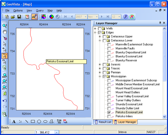
GeoVista enables you to identify
the names of the edge layers that appear in your map. These layers appear
as lines on your map and show you the erosional limits, subcrops, inliers,
and outliers of specific geological formations that have been regionally
mapped for Alberta (For example, Mississippian Easternmost Subcrop and
Leduc Pinnacle Reef). These edges give you method for determining whether
to expect specific formations to occur in a particular well or area. GeoVista arranges the layers by geological
age in the Layer
Manager tab.
- You need a license to view edge layers. Please contact Divestco
Support for more information.
Follow these steps to use the line selection tool to see the name of
edge layers in your map:
- It's easier to see
edge layers if you've turned off the view of all other layers. Therefore,
before you follow these steps, you should hide the other layers. .
- In the Layer
Manager tab on the Object
Manager bar, make sure the Edges
layer check box is selected, so that all edge layers display in your map.
- From the Map
Tools toolbar, select
 to change your cursor to
a zoom tool.
to change your cursor to
a zoom tool.
- On the map, click and drag your cursor over an
area with many edge lines to draw a medium-sized rectangle that represents
the area you want to zoom in to.
- From the Map
Tools toolbar, select
 to set your cursor to select
lines.
to set your cursor to select
lines.
- Click on an edge layer to display its name in
the map. The label will disappear as soon as you click anywhere else on
the screen.
What do you want to do?