Open topic with navigation
Select Coordinates
Use the Select
Coordinates tab on the Select Print Area dialog
box to set the
you want to print from your current Map View.
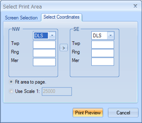
This tab has the following options you can use to define the location
of your area:
- NW
and SE - From the NW and SE
lists, choose the grid you want to use for each corner of your map. Your
options are DLS or NTS.
- You can set a different coordinate system for each corner. For example,
you can set the NW coordinate
to DLS, and the SE
coordinate to NTS. This might
be necessary if your area spans both coordinate systems.
- Options - If you want to use a DLS grid, you must
enter the Twp (township), Rng (range), and Mer
(meridian) information. Read more.
- Options - If you want to use an NTS grid, you must
enter the P Blk (primary block),
Quad (lettered quadrangle),
16th (sixteenth portion), and Blk (block) information. Read
more.
- Fit
Area to Page - Select this option if you want GeoVista to automatically scale your selected area to fit your current template's
page size.
- Use
Scale 1: - Select this option if you want GeoVista to scale your map to a specific size. Regardless of your scale, the center
of the map will be the center of your specified area.
What do you want to do?