 View image
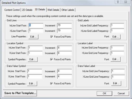
How to open the 3D details tab
 to open the Print Map dialog box.
Edit these parameters to control the in-line/cross-line grid density.
For example, if you set In-line Ref = 10, In-line Increment = 10, X-line Ref = 10, and X-line Increment = 20, then as a result you will get in-lines 10, 20, 30, etc. and cross-lines 10, 30, 50, etc.
Edit these parameters to set the label frequency of your in-line/cross-line grid lines.
Edit these parameters to set the frequency of in-line/cross-line intersection symbols.
For example, if you entered In-line Ref = 10, In-line Increment = 20, X-line Ref = 10, and X-line Increment = 40, you would see the following results:
| in-line10/ cross-line10, in-line10/ cross-line50, in-line10/ cross-line90, etc. |
| in-line30/ cross-line10, in-line30/ cross-line50, in-line30/ cross-line90, etc. |
| in-line50/ cross-line10, in-line50/ cross-line50, in-line50/ cross-line90, etc. |
Edit these parameters to set the label frequency of your in-line/cross-line intersections. ProductName will place the labels next to 3D intersection symbols based on the increment you select.
Edit these parameters to control the numeric 3D horizon value symbols at the in-line/cross-line intersections.
For example, if you set In-line Ref = 10, In-line Increment = 20, X-line Ref = 10, and X-line Increment = 40, then you will see the following results:
| in-line10/ cross-line10, in-line10/ cross-line50, in-line10/ cross-line90, etc. |
| in-line30/ cross-line10, in-line30/ cross-line50, in-line30/ cross-line90, etc. |
| in-line50/ cross-line10, in-line50/ cross-line50, in-line50/ cross-line90, etc. |
Edit these parameters to control the frequency of numeric 3D horizon values posted on your map at the in-line/cross-line intersections.
What do you want to do?