Open topic with navigation
Importing Well Surveys
These instructions will assume you
already have a well-spot for your
survey.
Well surveys are imported from ASCII files or hand entered, and consist
of a UWI, borehole
ID, measured depth, inclination, and azimuth.
Click here
for an example of the well survey format.
- From the Applicationtoolbar select
 |. The Well
Spot Database window will open. It contains a list of the wells in
your project and their properties.
- Highlight the well you want to import
a survey for, and click <ASCII
Import> and select .
- Select the source file for your well survey using
standard Windows commands.
- Click <Open>. The Define ASCII Format dialog box will open. The
first line of the Parsed Output
section should consist of a record with a UWI,
borehole ID, measured depth, inclination, and azimuth. If your parsed
output does not look like this, you need to define the ASCII format.
- Click <OK>. A check mark will signify that an association
has automatically been made between the well ID and survey record.
- If
an X appears in the
Match column, highlight the selected
well and click <Make Association>
to manually associate the selected well with the survey file record.
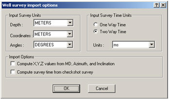
- Click <OK> to open the Well survey import options dialog box.
 View image

Input Survey Units
Select the correct depth, coordinate, and angle units to define the
survey record.
Import Options
Compute X,Y,Z,
values from MD, Azimuth and Inclination
Select this option
if your survey record does not contain the fields for X-offset, Y-offset
and TVD. WinPICS
will calculate the values based on the information provided for MD,azimuth,
and inclination. Do not use this option if you are importing X-Offset,
Y-Offset, and TVD, your import values will be overwritten.
Compute survey time from checkshot
survey
- Select the option to compute survey time if there is an assigned checkshot
for the well. WinPICS will grey
out this option if a checkshot is not detected.
- If you do not have a checkshot for this well you will need to import or
hand enter checkshot information and then use survey functions to compute times for your survey. Do not use this option if you are importing
time with your survey, your times will be overwritten.
- Click <OK>.
- Click <Save> to save the imported well survey and close the Well-spot Database.
What do you want to do?
 |Well
Database. The Well
Spot Database window will open. It contains a list of the wells in
your project and their properties.
  View image
 |Well
Database. The Well
Spot Database window will open. It contains a list of the wells in
your project and their properties.
  View image