Open topic with navigation
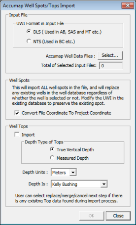
Accumap Well Spots/Tops Import
 View image

 How to open the accumap well spots/tops import dialog box
- On the Application toolbar, select to open the Well Spot Database dialog box.
- Click <Import ASCII> and select .
Select well spot or well tops (AXP) files for import
Select input file
- Select the UWI coordinate system (DLS or NTS) WinPICS will use for the well spot or well tops file.
- Click <Select>
to open the Select
ASCII File to Import dialog box, where you can browse to your directory
and select the AXP files you want to import. When you select a file WinPICS displays the number of well tops or well spots on the file.
Import well spots
- Select the Convert File Coordinate... check box to have WinPICS
convert the AXP file from lat/long to coordinates.
Import well tops
- Select the Well Tops check box.
- Select True Vertical Depth or Measured Depth for your depth type.
- Select a unit of measurement for depth.
- Select a depth reference for elevation.
- Click <OK> to import the well data to the Well Spot Database.
What do you want to do?
 View image
 How to open the accumap well spots/tops import dialog box