Open topic with navigation
Map Window
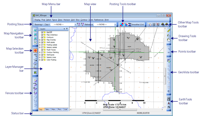
When you open a project, WinPICS
automatically opens a Map window. Click on the areas of the following image to
learn more about the areas of the Map
window.

To see more than one Map
window, click  on the Application toolbar.
- If you close all your map windows, the WinPICS
project will automatically close, but WinPICS
will remain running.
Working in the map window
The Map window has a number of functions:
- Posting Horizons/Faults – Use WinPICS
hot-keys to quickly walk through the horizons and faults in your horizon/fault
database, then post them to your map.
- Creating and Displaying Fences – Create fences to display
segments of 2D lines, 3D in-lines and cross-lines, and/or synthetic well
traces side-by-side in a seismic window. This is useful for tying seismic lines, comparing seismic versions, displaying
random traverses, and overlaying synthetics
on seismic.
- Selecting Seismic – Select to pick from only 2D lines, in-lines,
cross-lines, or well synthetics on the map window. Alternatively, select
to pick from all lines on the map window or from a list of line names.
- Posting Time and Horizon Slices – Post time and horizon slices
from an amplitude slice file. All slices for the time range you specify
are calculated at once, allowing you to step through the slices at any
increment you choose without having to recalculate slices. Time slices are posted relative to a start time, while horizon slices are posted relative to a picked horizon. Post horizon
and fault interpretation and fault contact points on the slice data.
- Posting Consistency Slices – Consistency slices are a
statistical measure of the trace-to-trace similarity. Post consistency
slices to examine fault edges, locate anomalies, or
identify data problems. They can be posted on the fly from existing
amplitude slice files to save disk space or from a pre-calculated consistency
slice file to save posting time. Post horizon and fault interpretation
and fault contact points on the slice data.
- Creating Gridded Horizons, Posting Gridded Horizons, and Marking Contours – WinPICS provides
a robust means of gridding time or amplitude horizons for contour marking,
mathematical operations, or export to other mapping applications.
- Picking Fault Traces
- Pick fault traces along contact points calculated from faults you mark
on your seismic section.
- Posting Isochrons and Amplitude Ratio Maps – Isochron and amplitude ratio
maps are created by posting a horizon on the map window and selecting
a ‘reference’ horizon. WinPICS
subtracts the reference horizon from the posted horizon for an isochron
map or divides the posted horizon by the reference horizon for an amplitude
ratio map. The calculation is fast and allows you to quickly view other
isochrons and amplitude ratios of the reference horizon and other horizons
in the database.
- Dip/Azimuth Wizard - Create Dip and Azimuth maps for 3D Horizons and Grids.
- Ranking Map Wizard - Used to compare up to five similarity maps. The maps
are ranked according to their cross correlation value.
What do you want to do?


 on the toolbar.